Chapter 3: The Country
I’ve written this article backwards in a way, by starting first from only the city itself and before now affirming the location of this region as a whole, but I thought it would be more exciting to address the city first with it being the most memorable and elucidating part of the story. Nonetheless, the regional descriptions are just as rich and make for perhaps even more alignments again.
“The land under the sun”
Plato makes plentiful descriptions of country which we will briefly remind ourselves of again here. Plato describes the land as follows:
- Island (nesos has also occasionally been used for island-like peninsulas)
- Larger extent than Libya and Asia (Minor)
- At/outside the Strait of Gibraltar (“pro the Pillars of Heracles”)
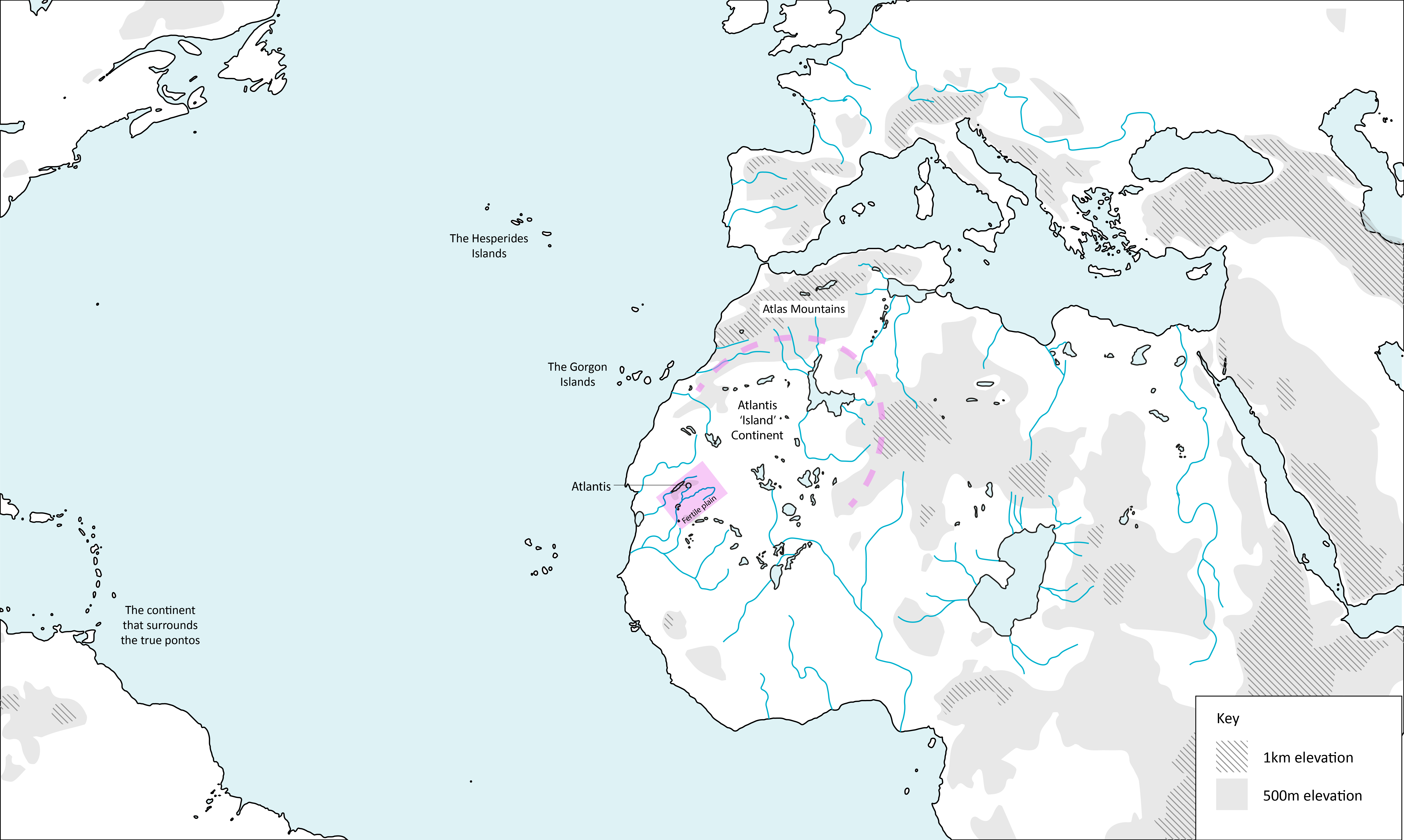
- Islands are placed between Atlantis and America (“from Atlantis you could sail to other islands and from these to the continent beyond which surrounds the true pontos”)
- Country was lofty and precipitous on the side of the thalassa.
- Described as the “Land under the sun”
- Mountains to the north of the plain “celebrated for number, size, and beauty,” and surrounding the southern region of the island
- The island was open to the south
- Mountains descend towards the thalassa.
- Climate allowed for two harvests per year.
- Elephants were present in great number.
- Gold and red ‘orichalcum’ (copper alloy) were abundant.
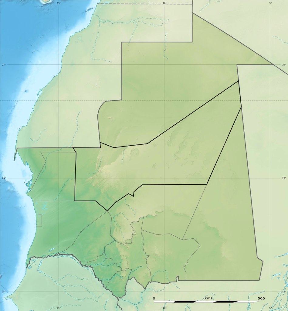
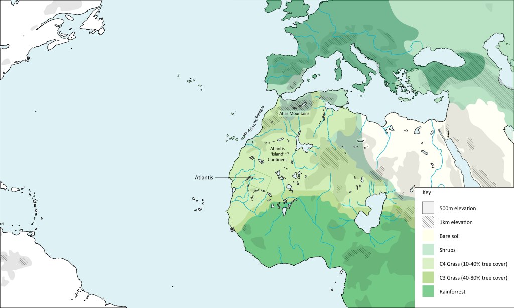
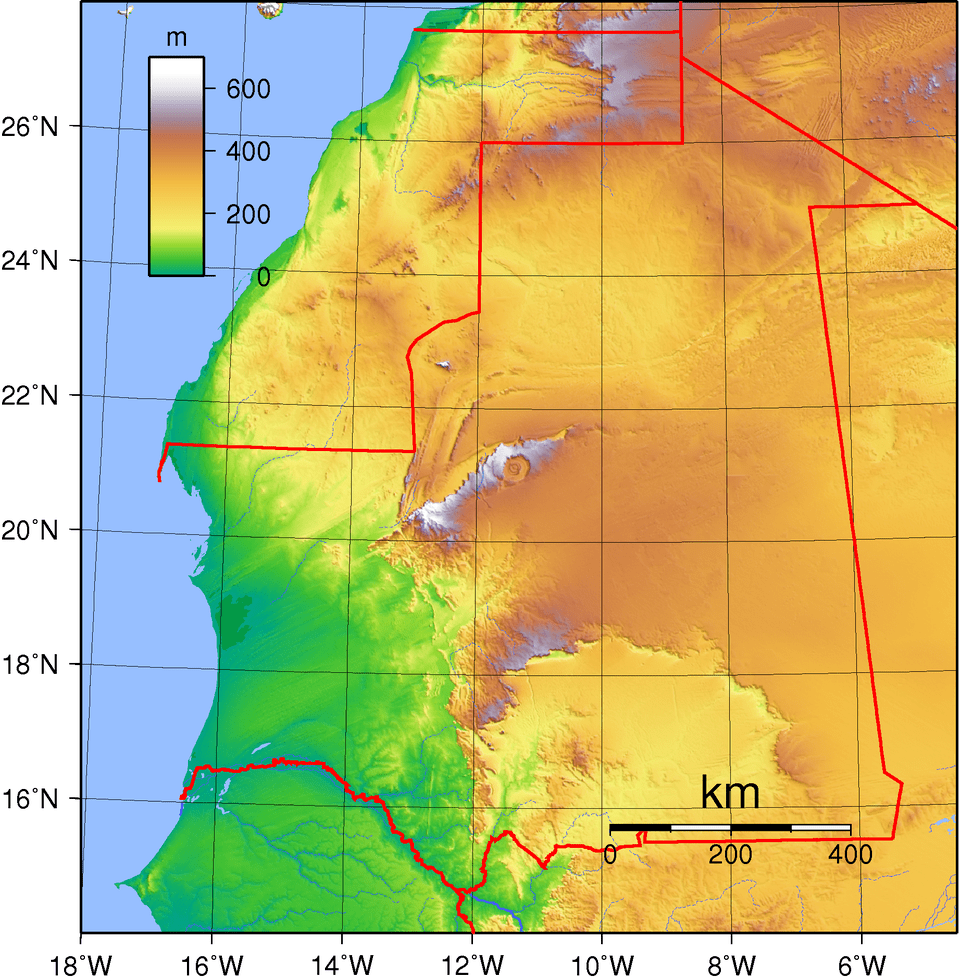
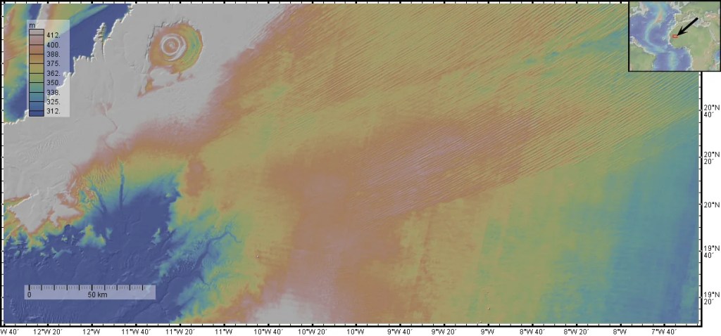
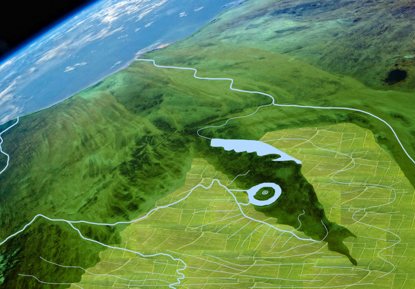
Below is a map of the topography and water bodies of approximates 7000 BC. The area was host to a swath of now extinct lakes and rivers due a climatic event called the African Humid Period (AHP) that will be discussing in a following section. Marked in pink is a geographic boundary line of encircling northern and eastern mountain with the past ‘Megreb Sea’ in-land lake in between. The rectangle below is the size Plato gives us of the fertile plain with the Richat Structure within this on the left, the plain’s placement here will be discussed in later sections.
In this conferment we can see geography that is reflective of the description we receive; a region larger than Libya (North Africa) and Asia (Turkey), the distance from the Atlas Mountains to below the plain is indeed larger (accounting for the slight warping of flat projection maps, shrinking equatorial regions). The region of the plain and city is said to lie towards the south of the island, this region is surrounding by mountains and open to the south. The mountains are, all-be-it, far away from the plain but relative to the vast scale of this land and plain this description makes sense.
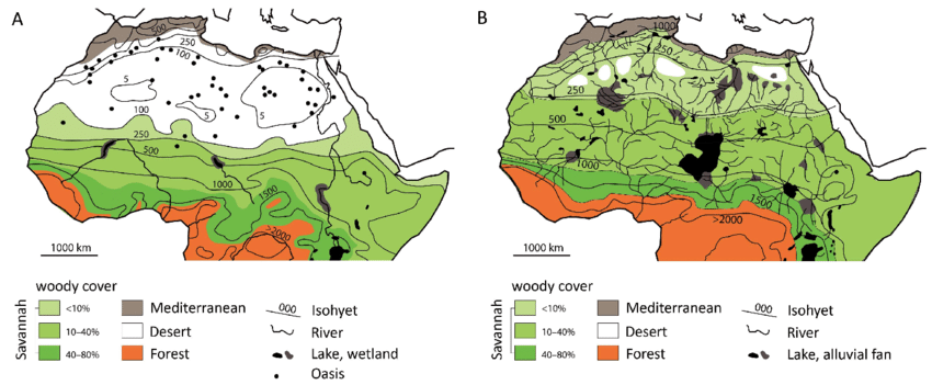
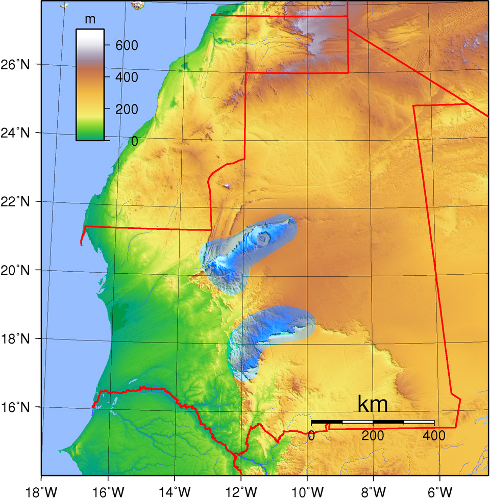
The images below show Africa today and a model of the biomes during the height of the African Humid Period in approximately 7000 BC. The image is from this 2020 paper:
Cerny, V., Fortes-Lima, C. and Tříska, P., 2020. Demographic history and admixture dynamics in African Sahelian populations. Human Molecular Genetics, 30. https://doi.org/10.1093/hmg/ddaa239
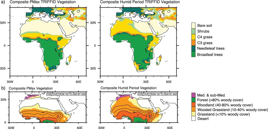
These are more images actual comparing biomes today to the height of the African Humid Period from a more recent 2023 paper:
Armstrong, E., Tallavaara, M., Hopcroft, P.O. and Valdes, P.J., 2023. North African humid periods over the past 800,000 years. Nature Communications, 14, 5549. https://doi.org/10.1038/s41467-023-41219-4
Overlaying the 2023 paper’s model onto a clearer map of the world results in the following diagram:
Sinking of the island
I want to start off by addressing the least conducive geographic descriptions to Mauritania, as of course the country is described as an island, moreover an island that sank! How can this be?
Here we address both the term island and the sinking of said island in turn. The term island was a strange misnomer that the region gained (I don’t make the rules). We have evidence that the close-by region of the Maghreb has long been referring to as an “island” ( Jazīrat al-Maghrib ) in Arabic as a geographic metaphor, this is real and attested. Here, the island metaphor is due landlocked nature of the fertile region; with a sea barrier to the north and west and barren mountainous barriers to the south and east.
If we look at the lower region below the Atlas mountains a similar picture can be seen; mountainous barren regions aligned the north and east (even during the AHP these were dry, impassable regions), to the west is the sea and although it is open to the south the descent into the topics was neither favourable for farming or a connecting route back to Europe.
The only viable method of travelling to this region would have been by sea.
Side note: There is also hearsay, unverified rumour that the native Berber people of this region today, the Amazigh, have been known to term a region below the Atlas Mountains as an island. This claim was made by the late German independent researcher Michael Hübner. Hübner claims that the Souss–Massa plain, an area in Morocco below the Atlas Mountains, was locally called “the island” by Amazigh people.
So why hasn’t it sunk?
This is another linguistic issue. As discussed in the previous chapter, the city of Atlantis was also an island, a true island, and is also referred to with the same term, Atlantis.
African Humid Period and Timings
Contrary to common awareness the AHP did not result in a sudden, uniform verdant North Africa from 12000 BC to 6500 BC but was intermittent and slowly develop. The region I’m interested in the Adrar region of Mauritania. Here, like much of North Africa, the AHP only took significant effect after the Younger Dryas, ramping up over the millennia from 9500 BC onwards.
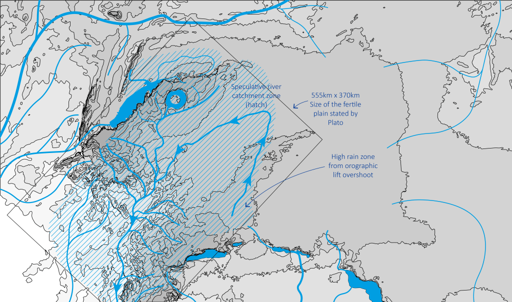
Ornographic Lift
Plato describes the country and a large 555km x 370km fertile plain with seasonal rain but still sufficient water to maintain a river annually and for the land to be used for two harvests per year. He also describes meadows supporting a range of animals.
There’s no way this kind of verdant landscape could form with less than 600mm of rain per year. For reference:


Left image: Spain with 300mm/year. Right image: Spain with even 700mm/year.


Left Image: Spain with 900mm/year. Right image: Spain with 1000mm/year
900 or 1000mm/year look like the closest matches to Plato’s description. So it’s strange that even at the peak of the African Humid Period the rough rainfall estimates found online suggest the area around the Richat are often predicted at around 300-400mm/year, in 7000 BC (the peak) that’s not enough.
The below table contains (my own crowd sourced reference) approximations for annual precipitation ranges for the Adrar region in 500 year increments created using AI to reference available studies. The precipitation threshold for arid or desert is 250mm of precipitation per year. The upper precipitation threshold for semi-arid (such as the Australian Outback) is 400mm of precipitation per year.
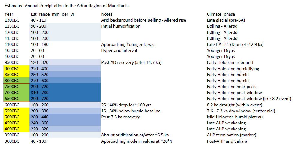
Large Prediction Range
You might note that the error bar range is very high, this is because for this region of Africa there is limited precipitation data. Precipitation data is most reliably obtained from measuring past paleolake levels and in this region few have been measured.
The other two data sets we have are pollen samples and off-shore Sahara dust deposits. Pollen samples indicate whether grasses or closed-canopy tree cover are dominant, this region fluctuates between desert and grassland but never entering closed-canopy tree cover. Sahara dust deposits indicate how arid the region was and therefore this is a good proxy for approximating the rainfall during the more arid periods.
It is really only the pollen sample data that provides an upper limit to the rainfall, as beyond a certain amount of annual precipitation closed-canopy tree cover becomes inevitable. However, we also know that for this region, like much of North Africa, rainfall was seasonal due to paleoclimate physics models and evidence of fire adapted ecosystems.
Concentrating annual rainfall into a wet season greatly increases the annual precipitation threshold required for closed-canopy tree cover dominance, raising it to approximately 1000mm/yr. This might explain why researchers have tended to cautiously assume precipitation averages at the lower range; as without factoring in strong seasonality the default assumption is that woodland biomes start at around 500mm/yr, half of the 1000mm/yr seasonal limit.
In the table the upper rainfall mean estimates are placed well below 1000mm/yr at a maximum of 780mm/yr, this is because rainfall broadly increases as longitudes approach the equator and there continued to be hundreds of kilometres of grass dominated biome before closed-canopy forest biome began.
Rainfall and Ornographic Lift
These estimates are regional averages. Local conditions can vary significantly.
Areas with sudden topographic rise induce rainfall through orographic lift, often increasing precipitation well above the regional mean.
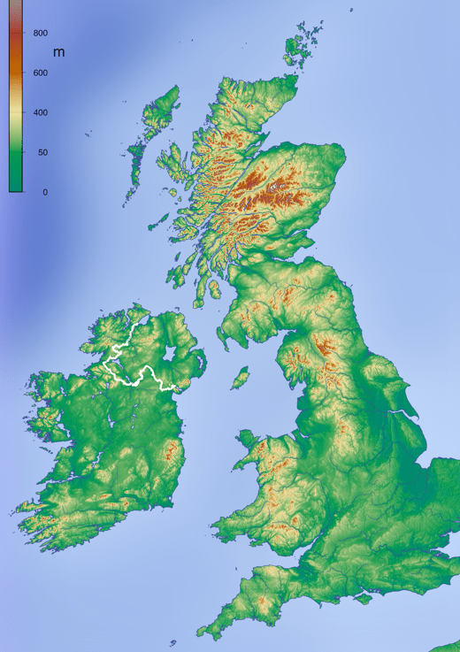
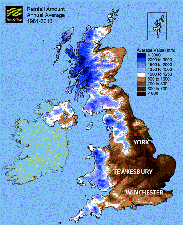
As shown in this images of the UK below. Average annual rainfall in England is 875mm/yr, this happens to match the upper end of the potential average annual rainfall in Adrar Mauritania in 7000 BC (potential range assumed to be 350 to 1000mm/yr of highly seasonal rainfall).
This effect would also have applied to the mountains/hills just south of the Richat which quickly assend from 50m to 550m. In such areas rainfall will often double or triple. Therefore, the region generally could have received 800mm/year average with a dry season preventing widespread woodland establishing, and mountains that rise suddenly could have received more like 1600-2400mm/year. This sounds a lot more like the environment Plato describes.
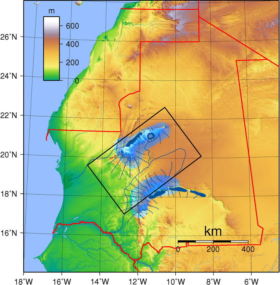
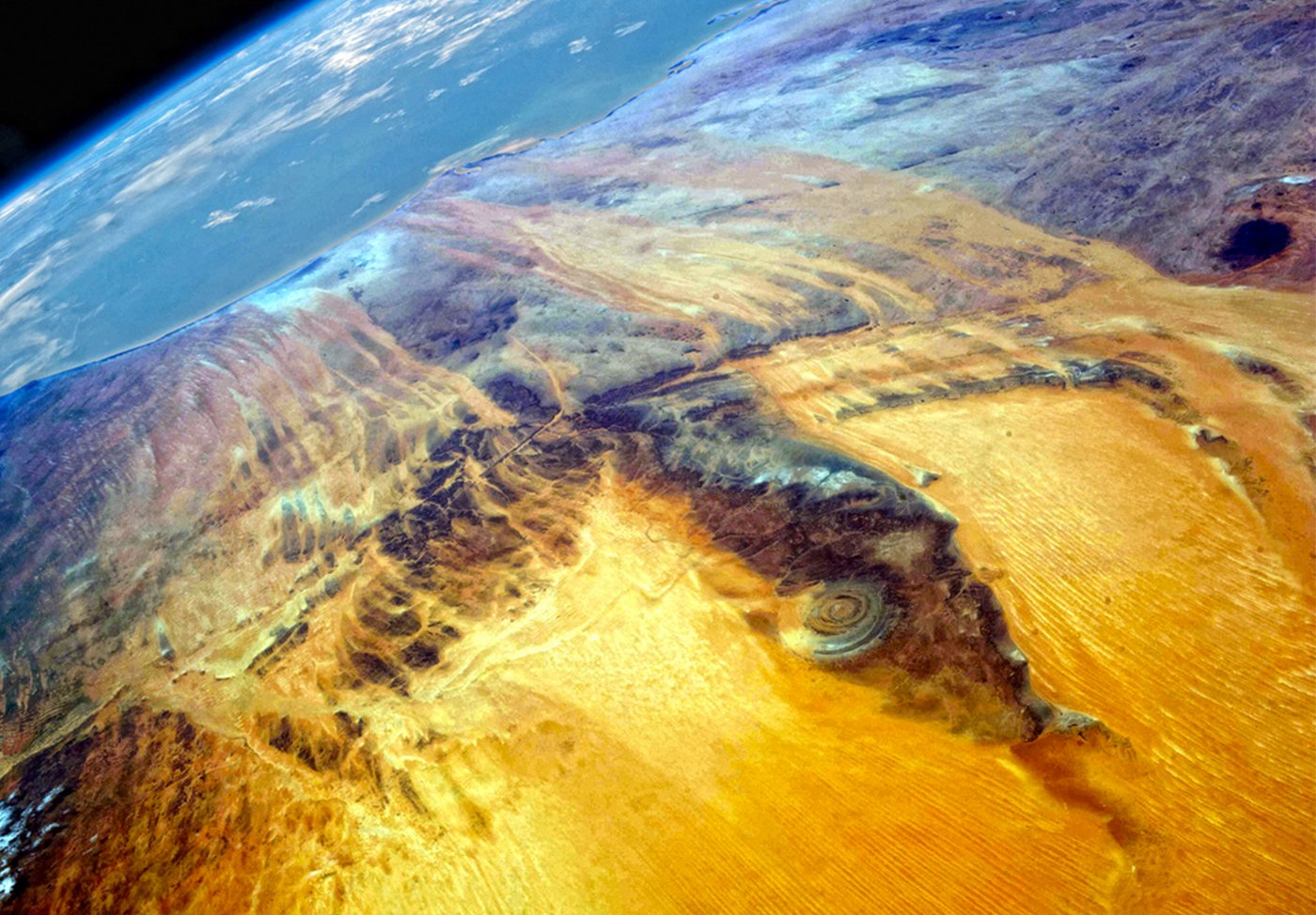
Below is the topography of the area around the Richat. The fertile plain is 3000 x 2000 stadia which at 1 stadion = 185m equates to 550 x 370km. Each square is 200 x 200km so this fertile plain would be 2 and a half by one and a half squares.
We can infer similar peak rainfall areas to be in these elevated areas shown on the map on the right in blue. These areas may have received 2x to 3x region average rainfall. If the regional average is 700mm/yr in 7000BC then these areas could have received 1400-2100mm/yr.
I had previous suspected that this fertile plain would be in the large flat rectangular brown area just to the right of the Richat but I now think it more likely aligned to the valley from the green zone to the brown zone.
We can assume streams paths down from these regions as shown and the placement of the fertile plain around this most naturally irrigated area. Placed here so that during the dry season this area would have continued to receive stream water.
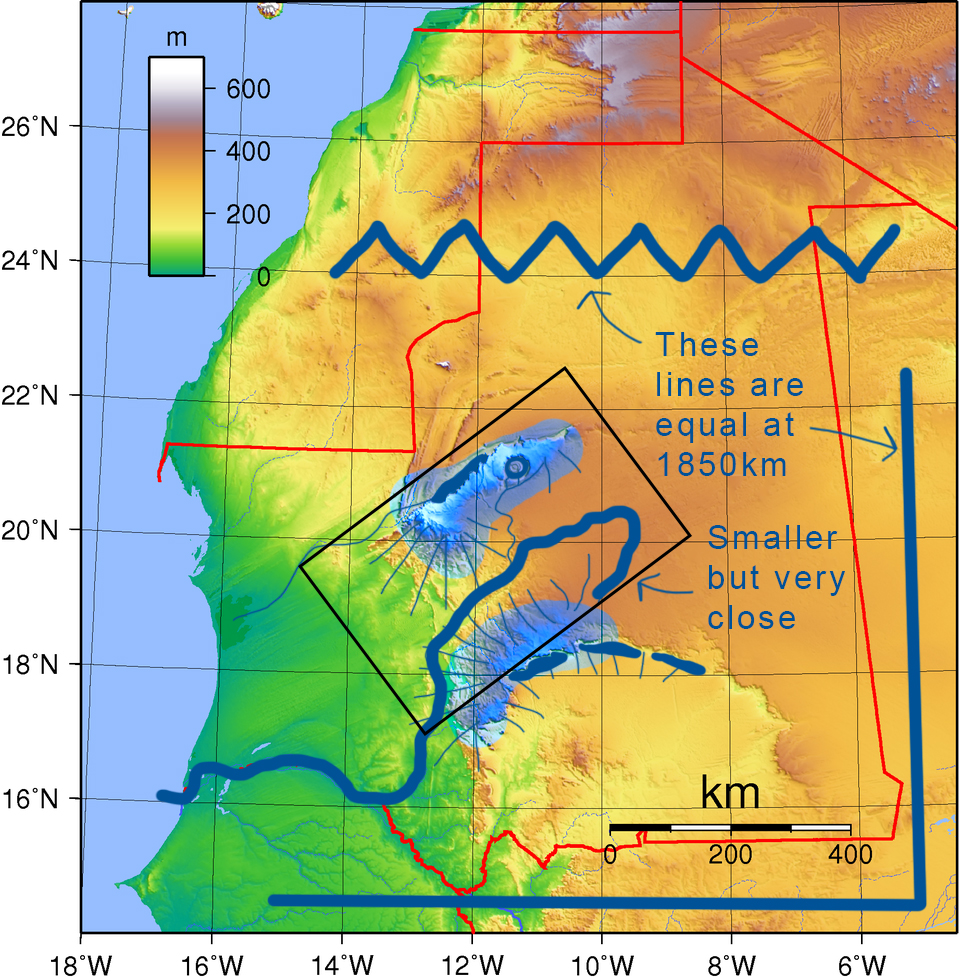
We are also given the information that the stream that continues through the plain is 10,000 stadia long in total. This equates to 1850km when using 1 stadion = 185m, approximately the length of nine squares. I’ve shown this length for comparison. The length of the river in this area looks slightly smaller but is pretty close. Of course if you measure every bend of a river the measured length can increase massively.
Zooming further in again below is a more accurate topographical map I was kindly sent by someone. It’s a bit greyed out so increased the saturation in the next image to make subtle changes in the area of the plain more obvious.
This next image includes speculative watercourse routes taking the assumption that the high areas would have received more than twice the rainfall than the lower areas. I also assume that the diagonal indentation we see in the topography may have been the route of a extinct river fed by streams from the hill to the south.
The next image zooms back out to look more broadly at where the full 555 km x 370 km fertile plain may have been located.
Due to the heat, evaporation of open water in this region is 4m per year. Therefore, to maintain lake levels in the Richat annual rainwater inflow would need to exceed this amount.
25% of the of the lake surface would be covered by peat reducing evaporation by about 20%. Reducing total evaporation to 3.2m/yr.
The catchment area on the plateau is about 4.5 times the size of the lake itself. Normal runoff coefficient can be assumed to be 25%.
In this case some water permeating in the soft carbonate/sandstone would also reach the lake as spring water, we could assume this to be approximately 15% of rainwater in the catchment zone.
Combined rainwater coefficient could therefore be assumed as 40%.
Plugging in the numbers; to maintain water levels in the Richat 1780mm/yr would be required to fall on the plateau. This is high but would within the range of possibilities if regional average was equal or greater than 712mm/yr and if the plateau received 2.5x the regional average.
This is the same topography diagram again, zoomed in, with slightly more detail on topography and potential stream paths.
—
Plato describes a “1850km” long river meandering around the plain touching the city on side and side and then making its way towards the thalassa, what we can see int the topography aligns with these descriptions, apart from the 1850km as the diagonal length in the image would be a mere 300km. 1850km would align more precisely with the entire length of this river to where is would have connected to the Atlantic Ocean. You can see the full course this past river would have take in the image below.
These are the passages from Plato with descriptions of the river, plain and landscape:
“many wealthy inhabited villages, and rivers and lakes, and meadows supplying food enough for every animal, wild or tame, and wood of various sorts, abundant for every kind of work.“
“It was excavated to the depth of a hundred feet, and its breadth was a stadium everywhere; it was carried round the whole of the plain, and was ten thousand stadia in length“
“[the plain] was rectangular, and for the most part straight and oblong; and what it wanted of the straight line followed the line of the circular ditch.“
“[The ditch] received the streams which came down from the mountains, and winding round the plain“
“they brought down the wood from the mountains to the city, and conveyed the fruits of the earth in ships, cutting transverse passages from one canal into another, and to the city.“
“Twice in the year they gathered the fruits of the earth–in winter having the benefit of the rains, and in summer introducing the water of the canals.“
To be continued..
Chapter 4: The Empire
We’ve established the misconception of the war and dating of Atlantis, where the city was, how it came about, its demise and details of the country.
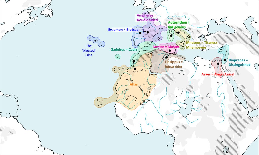
It might appear that a section on the empire is an unnecessary add-on, a speculative guess, however it’s not, we can be incredibly precise about the locations of the ten kingdoms of Atlantis with the information we are provided.
The most relevant passage from Plato on these kingdoms is below.
“He also begat and brought up five pairs of male children, dividing the island of Atlantis into ten portions: he gave to the first-born of the eldest pair his mother’s dwelling and the surrounding allotment, which was the largest and best, and made him king over the rest; the others he made princes, and gave them rule over many men and a large territory.
And he named them all: the eldest, who was king, he named Atlas, and from him the whole island and the ocean received the name of Atlantic. To his twin-brother, who was born after him, and obtained as his lot the extremity of the island toward the Pillars of Heracles, as far as the country which is still called the region of Gades in that part of the world, he gave the name which in the Hellenic language is Eumelus, in the language of the country which is named after him, Gadeirus.
Of the second pair of twins, he called one Ampheres and the other Evaemon. To the third pair of twins he gave the name Mneseus to the elder, and Autochthon to the one who followed him. Of the fourth pair of twins he called the elder Elasippus and the younger Mestor, And of the fifth pair be gave to the elder the name of Azaes, and to the younger Diaprepes.
All these and their descendants were the inhabitants and rulers of divers islands in the open sea; and also, as has been already said, they held sway in the other direction over the country within the Pillars as far as Egypt and Tyrrhenia (Italy).“
from Critias, Translated by Benjamin Jowett
Analysis
Each name has linguistic associations, they are listed here:
- Atlas = Atlas Mountains
- Gadeirus = Cadiz
- Ampheres = Double sided
- Evaemon = Blessed
- Mneseus = Mnemosyne (Titaness)
- Autochthon = Indigenous people
- Elasippus = Horse rider/chariot culture
- Mestor = Plan/Council
- Azaes = Angel Azazel
- Diaprepes = Distinguished
Pairing these regions as five sets of twins may not have been a random choice, rather, this might signify geographic similarities for each pair.
Likewise, even the ordering of the pairs as they are stated by Plato may not be random but set out by their geographical order in a radial arc stretching out from Atlantis.
With this in mind starting with Atlas:
Atlas is king of the ‘island’ of Atlantis; Mauritania to the Atlas Mountains.
Of Gadeirus Plato writes:
[Critias 114b] “To [Atlas’] twin-brother, who was born after him, and obtained as his lot the extremity of the island toward the Pillars of Heracles, as far as the country which is still called the region of Gadeirus in that part of the world”
Etymologically Gadeirus maps to Gades the root name of modern day Cadiz, this is another match that we’re given.
The next set of twins are Ampheres and Evaemon, we’re now arcing through Iberia.
Evaemon meaning “blessed” nicely links to the region of Portugal and the Azores given that the western reaches and islands of Europe have long been associated with the fabled ‘land of the blessed’ and the westerly island of Elysium.
Ampheres means double-sided, this maps very well onto the neck connecting Spain to France, Basque Country, the double-sided name relating to this region’s reach from the Atlantic to the Mediterranean.
The next twins are Mneseus and Autochthon, a word related to the Greek word for “memory tradition” or Titaness Mnemosyne and a word meaning “indigenous people”. Autochthon maps very well to Sardinia and Corsica given their strong cultural connection to district Pre-Indo-European peoples and settlement continuing into relatively recent times. Which leaves Mneseus as Italy. This name isn’t a strong fit to any region but given that Mnemosyne is a very important Goddess who births a series of the gods in the Greek pantheon, there is a rational for them to be close to Greece.
Mestor and Elasippus.
Mestor means master/planner/council, this is well placed as Tunisia given its central position between all other regions, therefore being well placed as a meeting point or council between peoples.
Elasippus means horse-driver which suggests a place with a history of horses and/or chariots. Libya has some of the oldest horse rock art and evidence of ancient chariot in the world, so of anywhere, this location fits very well.
Lastly Azeas and Diaprepes.
Azeas is the only word without an etymology but I think the word could link to Azazel, one of the Watches or fallen angels in Israelite tradition. Azazel is associated with the desert and brings knowledge of metallurgy to the the Israelites. Pre-dynastic Egypt has links to early metallurgy and is deserty, so this works well.
Diaprepes means distinguished which could map to south Levant. An area with some of the most ancient settlement and association to Hyperion or Elioun both meaning ‘Highest’, highest/distinguished are sort of similar in meaning.
The name meaning to the areas match is already strong and this sequence aligns with the paired and the ordering read out by Plato and the are matches the descriptor that the kingdom “once had an extent up to Tyrrhenian (Italy) and Egypt.” Therefore, the extent of the Atlantean empire can be asserted with confidence.
Poseidon vs Oceanus
This is right moment to discuss the myth’s sea deity. There is a lot of justification to suggest that the attribution of the deity to Poseidon was a translational error and that this deity figure was instead Oceanus.
Objecting against the validity of a statement in the original text requires adequate justification which is elaborated on in this section.
Firstly, Plato cautions us that the Greek names used in the account are translations from Egyptian originals.
[Critias 113a] “Yet, before proceeding farther in the narrative, I ought to warn you that you must not be surprised if you should hear Hellenic names given to foreigners.
I will tell you the reason of this: Solon, who was intending to use the tale for his poem, made an investigation into the meaning of the names, and found that the early Egyptians, in writing them down, had translated them into their own language, and he recovered the meaning of the several names and retranslated them, and copied them out again in our language.”
Therefore all Greek names in the story had been translated into Greek from Egyptian names based on their meaning, this includes this founding god.
Had the Egyptian account described Oceanus as “god of the sea” this could explain a mistaken attribution to Poseidon. Also, given Poseidon was the most recent ruler of the land of Atlas, following the Titanomachy, he may have already been associated with the region and this may have been known to Solon thus swaying his decision.
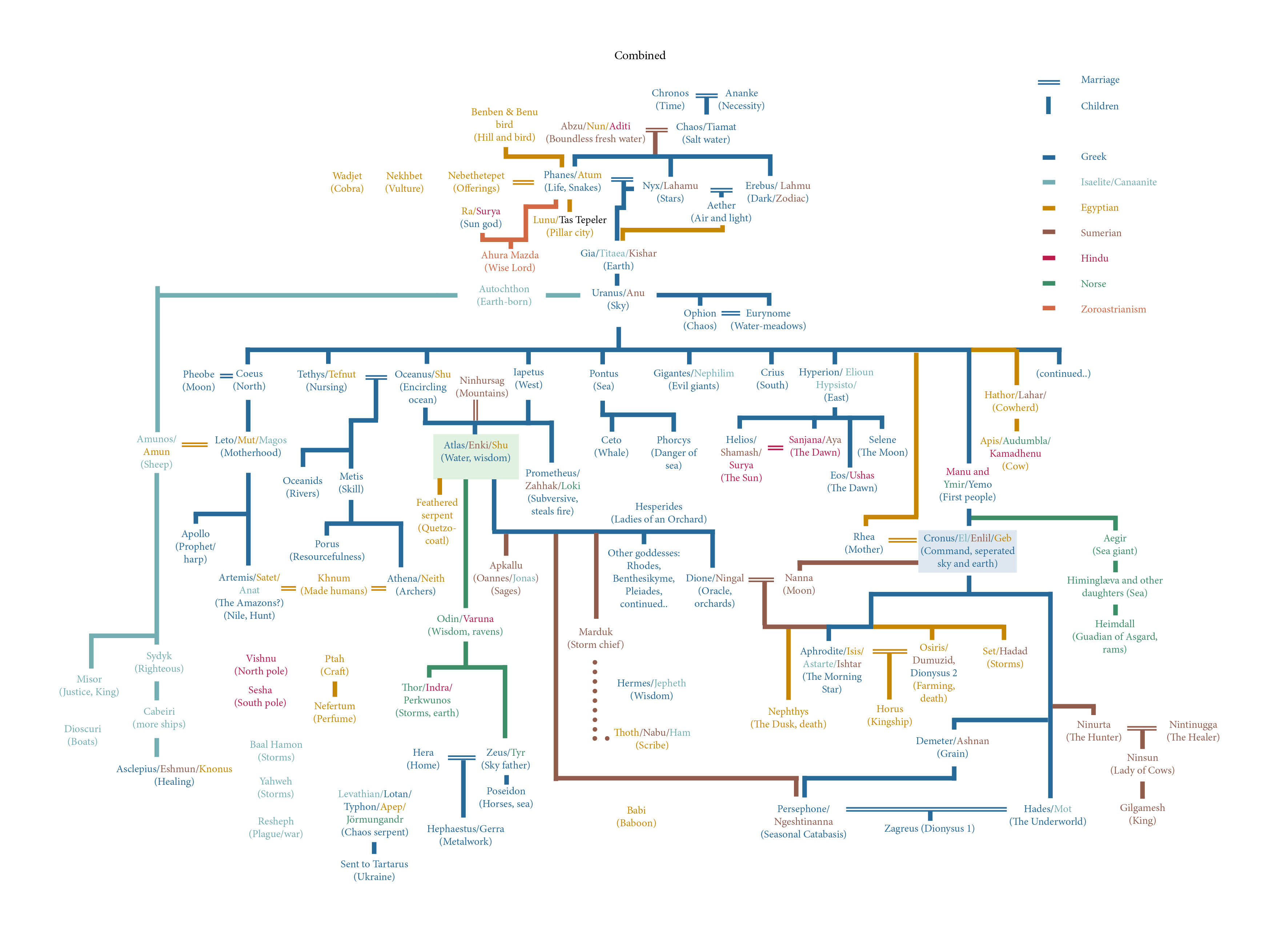
To make this judgment we need to understand more about each of these gods. This is an overview of both gods:
Oceanus:
- is the first Titan
- is the origin of the gods [according to Homer]
- is married to Tethys (goddess of freshwater)
- is the god of fresh water and founded all fresh water systems.
- is also associated with a world encircling ocean.
- is shown holding a snake in the earliest depiction (later shown as a sea-serpent).
- has horns in the earliest depiction (later shown as crab claws).
- is also shown holding a rudder or being an oar.
Poseidon:
- is born after Pontus who was born after Kronos (so a later generation god).
- is one of the twelve Olympians who overthrow the Titans.
- is married to Amphitrite (goddess of the sea who first avoids him but is eventually caught)
- is the god of the sea.
- is associated with the sea and horses.
- is shown holding a trident and riding a chariot
Accounts of Poseidon place him as a later generation god after the Titans. Therefore, either all these accounts are wrong and Plato’s account alone is correct or the other accounts of Poseidon are correct and Plato’s is wrong.
Oceanus is also reinforced as the correct founding god by the Egyptian theogony.
The Egyptian goddess Tefnut is goddess of moisture as is the Greek Titaness Tethys, therefore there is a strong implication that the two represent the same deity, reinforced by Herodotus who says that first generation of Greek gods are said to mostly be of Egyptian origin.
Given that Tefnut is the consort to Shu is may be assumed that Shu is a figure related to Oceanus. Shu is an early god that holds up the cosmos potentially aligning him to the figure of Atlas. If Oceanus were the founding figure of Atlas, Atlas would be closely related to Tethys and this might better explain the pairing of Shu and Tefnut as a close match by assuming the Egyptians merge Oceanus and Atlas into the same figure.
Oceanus as an origin or first Titan aligns with the role of Atlas from Plato and also Diodorus Siculus, as Diodorus Siculus describes ‘Atlantians’ as being the origin of the gods:
Diodorus, Library:
“Atlantians, the most civilized men among the inhabitants of those regions, who dwelt in a prosperous country and possessed great cities; it was among them, we are told, that mythology places the birth of the gods, in the regions which lie along the shore of the ocean”
To conclude, Plato tells us his Greek names might be wrong. Poseidon is a second generation god, one of the twelve Olympians, said to have replaced the Titans. Whereas Oceanus links to Atlas via Shu & Tethys, and as a founding figure of the Titans making him a much stronger match for this figure.
Further Egyptian Exploration
We can also make an assumption for which god the Egyptians may have been using for this god of the sea. Although to the Egyptians Oceanus may have been seen as the combined figure with Atlas, as stated above, they had their own god of primal waters who precedes their whole pantheon, the figure Nun.
Nun is tied into a founding Egyptian myth of the first man, Atum who is said to have risen from Nun to the Benben mound where Lunu (translating to ‘Place of Pillars’) was built.
CT Spell 714
“I am Nun, the sole one, without a second.
I am he who came into being in the beginning.”
Utterance 600
[to Atum] “You have emerged from the waters of Nun; you have come into being upon the primeval mound.”
Coffin Texts
[Atum speaking] “I was in Nun, in a state of inertness, before I found a place to stand.”
[Atum stands on the Benben Mound of the Bennu Bird]
It seems highly likely that Lunu represents the Tas Tepeler sites in Turkey given that iconographic continuity of spread vulture wings on Pillar 43 to similar iconography of the sun disk of Ra and Nekhbet depictions.
There could be a link between the origin story of the Atlanteans we recive from plato and this origin story of Egypt given that both feature a foundational figure coming from a god of the sea onto a mound and who is the ancestor to the rest of the gods.
It’s possible that had the Atlanteans arrived from a culture that originating at the Tas Tepeler sites this origin story had become corrupted over the preceding millennia and the aspects were reapplyied to the local environment of their foundational city of Atlantis.
The Titans
We can make the logical assumption at this stage that the Titans in Greek myth represent the same kings as the ten Atlantean kings. This idea is reinforced in a line from the historian Sanchunithan who’s work is recorded in Eusebius’ historical text, Preparation of the Gospels. Sanchunithan says:
“From them [the Technites (Artificer), and the Geinos Autochthon (Earth-born Aboriginals)]came husbandmen and huntsmen. They are also called Aletae and Titans.“
Aletae suggests etymological links to Atlanteans, and Titans means Titans as is made clear in other parts of the text.
We can make assumptions for which Titans correspond to which regions given what is known of them and their offspring. Therefore, we can make assumptions for which Atlantean kings correspond to which Titans.
There are 10 Atlantean kings plus the founding god and there are 12 Titans.
All 12 Titans are:
- Oceanus & Tethys = waters
- Coeus & Phoebe = intellect & prophecy
- Crius = constellations
- Hyperion & Theia = light & radiance
- Iapetus = mortality
- Cronus & Rhea = kingship & generation
- Themis = divine law
- Mnemosyne = memory
(Atlas is not a first generation Titan but instead the son of Iapetus.)
and the 10 Kings with meanings and locations again are:
- Atlas = Atlas Mountains
- Gadeirus = Cadiz
- Ampheres = Double sided = South France
- Evaemon = Blessed = Portugal
- Mneseus = Mnemosyne = Italy
- Autochthon = Indigenous people = Sardinia
- Elasippus = Horse rider/chariot culture = Libya
- Mestor = Plan/Council = Tunisia
- Azaes = Angel Azazel = Egypt
- Diaprepes = Distinguished = Levant
The only two that we can match with real confidence are:
- Atlas = Atlas
- Mneseus = Mnemosyne
Beyond these we can use the information we’re given to make good assumptions for the rest.
We can use what we know of the Titans and what we know of their descendants and the pairings of the Titans to assume the additional matches:
- Diaprepes = Hyperion (only other strong match as location of Hyperion is the Phoenian homeland)
Assumptions:
- Azaes = Theia (due to Hyperion & Theia coupling and children)
- Ampheres = Coeus (due to pole star link speculation and location of Pheobe)
- Evaemon = Iapetus (due to Iapetus west link speculation)
- Gadeirus = Themis (due to testimony of Tartessos’ having laws dating to 6500BC)
- Elasippus = Tethys (near Oceanus and by the wet Tritonis marsh)
- Mestor = Oceanus (due to Tethys location and descriptions of this area as Oceanus)
- Autochthon = Phoebe (near Coeus)
Regions beyond Atlantis that may have been added after Plato’s tale include:
- Anatolia region = Rhea
- West Anatolia / Greece = Cronos
- West Black Sea region = Crius
Short slideshow overlaying myth to migrations in Europe, Levant and Africa
The Tas Tepeler Sites
Background
The Tas Tepeler sites area collection of the earliest known examples on monumental architecture and date to approximately 9500BC. They are located in south Turkey and consist of stone pillars (or stele) in rings with two pillars generally in the centre of each ring. All pillars are caved with stone carvings, some of animals, some of symbols, some phallic and some to make the pillars look like standing people.
Gobeklitepe is most notable as it was the first to be discovered and is one of the oldest of these sites although the smaller Karahantepe has actually now been shown to be the earliest.
The sites were first discovered in 1994 by the German Archaeologist Klaus Schmidt. Klaus Schmidt died in 2014 by which time approximately 5-10% of Gobeklitepe and the Tas Tepeler had been excavated. Up to this point visitors were free to arrive and see the work.
After this the sites were handed over to the Turkish Ministry of Culture and Tourism, and in the 22 years since still only 5-10% has been excavated.
Relevance
The sites are relevant to Atlantis insomuch as they are evidence of these first foundational farming people who in the proceeding millennia go on to develop the different Titan kingdoms. The Tas Tepeler sites also sit perfectly on the dating we receive for the start of the war between those inside and those beyond the Pillars of Hercules, being 9000 years before Solon, therefore 9600 BC.
Previously we covered how this war could represent a slow war of attrition between arriving farming peoples and indigenous hunter-gatherer peoples. If the memory of this war is passed down to us via the Atlanteans then this dates corresponding to the Tas Tepeler sites could make sense as a significant date for these peoples, as the date they first unified and embarked on the mission of slow colonisation.
Historical Memories
The Tas Tepeler sites are mentioned in both Egyptian and Phoenician historical texts.
These are the Egyptian mentions:
Utterance 600
[to Atum] “You have emerged from the waters of Nun; you have come into being upon the Benben [primeval mound].”
Coffin Texts
[Atum speaking] “I was in Nun, in a state of inertness, before I found a place to stand in Iunu [place of pillars].”
Atum is the first man, the hieroglyphics used for Iunu translate to ‘place of pillars’. The Benben is said to be a primeval mound. The Tas Tepeler sites are the earliest ‘first man’ proto-civilisation sites, contain pillars and are built on mounds. Therefore there is a correlation between these passages of the earliest Egyptian mythic history and the Tas Tepeler sites.
The Phoenician mention comes from the Phoenician historian Sanchuniathon who was writing in 1300BC from compiled historical sources within temples in the Levant in this time. His work survives through copies made by Philo of Byblos and later Eusebius in his Preparation of the Gospels text.
In this work Sanchuniathon is quoted and describes a figure called Ousous, the first to invent the use of animal skin clothing and boats, and who was a good hunter. The account goes on to tell us that Ousous first created two pillars from wood dedicated to fire and wind and consecrated them, worshipped them and poured blood of wild beasts on them.
Eusebius – The Preparation of the Gospels
Full passage relating to the timeline up to Tas Tepeler sites is below and available at https://topostext.org/work/230#1.9.17:
[at a later time] “those who were left.. ..constructed ‘στήλας’ (‘stele’ – standing stones/pillars/monuments) and year by year worshipped their pillars and kept festivals in their honour.”
..Aeon and Protogonus, mortal men, so called: and that Aeon discovered the food obtained from trees. That their offspring were called Genos and Genea, and inhabited Phoenicia: and that when droughts occurred, they stretched out their hands to heaven towards the sun; for him alone (he says) they regarded as god the lord of heaven, calling him Beelsamen, which is in the Phoenician language “lord of heaven,” and in Greek “Zeus.”’
§ 1.10.6 And after this he charges the Greeks with error, saying: ‘For it is not without cause that we have explained these things in many ways, but in view of the later misinterpretations of the names in the history, which the Greeks in ignorance took in a wrong sense, being deceived by the ambiguity of the translation.’
§ 1.10.7 Afterwards he says: ‘From Genos, son of Aeon and Protogonus, were begotten again mortal children, whose names are Light, and Fire, and Flame. These, says he, discovered fire from rubbing pieces of wood together, and taught the use of it. And they begat sons of surpassing size and stature, whose names were applied to the mountains which they occupied: so that from them were named mount Casius, and Libanus, and Antilibanus, and Brathy. From these, he says, were begotten Memrumus and Hypsuranius; and they got their names, he says, from their mothers, as the women in those days had free intercourse with any whom they met.’
§ 1.10.8 Then he says: ‘Hypsuranius inhabited Tyre, and contrived huts out of reeds and rushes and papyrus: and he quarrelled with his brother Ousous, who first invented a covering for the body from skins of wild beasts which he was strong enough to capture. And when furious rains and winds occurred, the trees in Tyre were rubbed against each other and caught fire, and burnt down the wood that was there. And Ousous took a tree, and, having stripped off the branches, was the first who ventured to embark on the sea; and be consecrated two pillars to fire and wind, and worshipped them, and poured libations of blood upon them from the wild beasts which he took in hunting. ‘But when Hypsuranius and Ousous were dead, those who were left, he says, consecrated staves to them, and year by year worshipped their pillars and kept festivals in their honour.
Explanation
Sanchuniathan is explicit that he is describing the land of Phoenicia (an area within close the proximity of Anatolia), and is describing the emergence of the first farming peoples up to the gods (who he equated with past kings). The description of these στήλας ‘stele’ would appear align with what we know of the Taş Tepeler pillars.
The dedication of the original two wooden pillars to wind and fire is an interesting detail. This raises the possibility that the blowing figure shown on the north wall of Karahantepe may represent the wind.
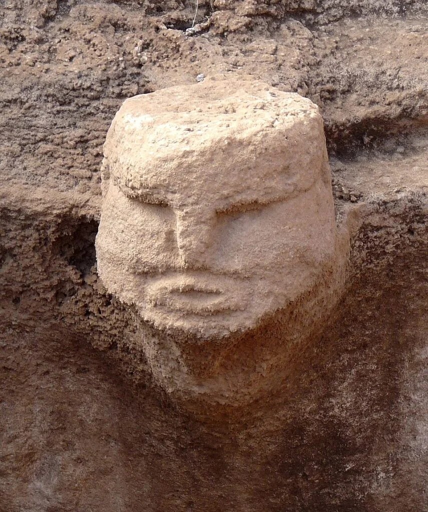
GT06_P43_N09.32_ 600_A4.jpg
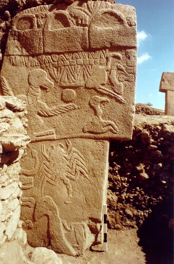
Left: figure shown on the north wall of Karahantepe, potentially representing the wind
Right: Pillar 43, a calendar with half circles and animals at the top potentially denoting a sacrifice schedule
The detail of the blood of wild beasts being ceremonially poured onto at least the first pillars could also help explain the three animals and semicircles at the of on Pillar 43. These have been suggested to represent each solstice and the equinoxes and may show which animals to sacrifice at these times.
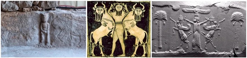
Klaus Schmidt, the original archaeologist of the Tas Teleper sites, before his passing, had speculated that the iconography may link to later Egyptian iconography although the topic remained somewhat verboten as Egypt don’t like the idea of their culture deriving from another culture. The Turkish Ministry of Culture and Tourism and Lee Care now deny such equivalences. However, similarities are shown below and you are free to make your own assumption.
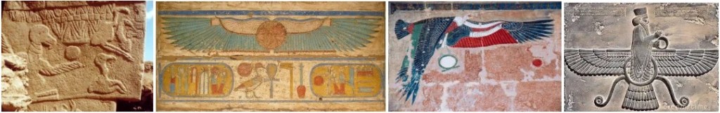
Additionally, a frieze on the wall of Gobeklitepe has been likened to a Mesopotamian ‘master of animals’ motif.
The official line is that because is is impossible for mythic information to be transmuted over 7000 years the account from Sanchunithon is made-up and the Egyptian Mythology regarding predynastic figures is also made-up, there is no connection between Egyptian, Greek or Mesopotamian cultures. Any similarities in depictions are coincidences.
Conclusion
The pillars to the hunter Ousous mentioned by Sanchuniton and Atum’s Lunu (the place of pillars) mentioned in Egyptian myth both appear to point to the Tas Teleper sites. We can’t say for certain these are links, but they appear to be. The figure in Karahantepe appears to be the wind. There also appear to be an iconography connection btween the reliefs in Gobekliepe and later Egyptian and Sumerian art.
This links to Atlantis insomuch as Sunchunithan includes the Aletae (as equivalent to the Titans) as well as and discussions of Atlas later in his timeline.
the Titans, the Anunnaki, the Apkallu, the Elohim, Jonas and the Whale, and the Serpent.
Sanchuniathon-Plato Crossovers
Before moving on from this account from Sanchuniathon it’s also worth noting the similarities between the account and the account we receive from Plato. Both talk of two pre-Atlantean classes of people, Earth-born people and craftsman born from Hephaestus.
Sanchuniathon in Eusebius’ The Preparation of the Gospels
[In the account up to this point there have been: primal gods → Ousous (pillars) → Agreus and Halieusthere (hunting and fishing) → Hephaestus and Zeus Meilichios (no that Zeus)]
“Afterwards there sprang from their [Hephaestus and Zeus Meilichios’] race two youths, one of whom was called Technites (Craftsmen), and the other Geinos Autochthon (Earth-sprung people). These devised the mixing of straw with the clay of bricks, and drying them in the sun, and moreover invented roofs.
From them others were born, one of whom was called Agros, and the other Agrueros or Agrotes; and of the latter there is in Phoenicia a much venerated statue, and a shrine drawn by yokes of oxen; and among the people of Byblos he is named pre-eminently the greatest of the gods.
These two devised the addition to houses of courts, and enclosures, and caves. From them came husbandmen (farmers) and huntsmen. They are also called Aletae and Titans.
From these were born Amynos and Magus, who established villages and sheepfolds. From them came Misor and Suduc, that is to say “Straight” and “Just”: these discovered the use of salt (used for preserving food, bathing and healing wounds)”
[Timaeus 23d -25c]
[The Egyptian preist is speaking to Solon at Sais.]
“..of your city [Athens] I will speak..and this one [Egypt]—yours first; a thousand years earlier [than the founding of Egypt], having received your [Greeks] seed from Earth and Hephaestus, and this one [Egypt] later. And of the ordering here among us, the number of years written in the sacred records is eight thousand. Concerning the citizens of nine thousand years ago, I will briefly set forth their laws and the noblest deed accomplished by them; but the exact account of everything we shall go through later in due order, taking up the written records themselves at our leisure. Now consider their laws in comparison with those here; for you will find many examples among us now of what existed among you then: first, the class of priests set apart separately from the others, and after that the class of craftsmen, each working on its own without mixing with others, and the class of herdsmen and that of hunters, and of the farmers.”
[later on]
“..the records tell how great a power your city once halted when it advanced in insolence against all Europe and Asia at once, having set out from outside from the Atlantic pelagos.“
“..in this island of Atlantis there arose a great and marvellous power of kings, ruling over the whole island and many other islands and parts of the continent; and besides these they also ruled over the lands within here. ..All this power, gathered together into one, once attempted with a single assault to enslave your land and ours and all the region within the strait.”
[later on]
“But at a later time, when extraordinary earthquakes and floods occurred, in a single day and night of grievous calamity, all your warrior force together sank into the earth, and the island of Atlantis likewise sank into the thalassa.”
In Sanchuniathon, after Ousous (of the Tas Tepeler culture (9600 BC)) come the Technites (craftsman) and Autochthon (Earth-sprung people) who are born from the generation of Hephaestus. With the Aletae (or Titans) then coming after this.
In Plato’s account, in 9600 BC, the Greeks were born from Earth and Hephaestus forming craftsman, farmers and herdsman. With the Atlanteans then showing up after this.
Both claim farming people and craftsmen were born from the Earth and Hephaestus in 9600 BC, and both claim the Aletae or Atlanteans then arrive after.
Plato’s account, also claims that in 8600 BC the Egyptians were born. The account states that the Greeks halt the advancement of the Atlantean Kings, defending both their own people and these Egyptians.
If the Egyptians existed from 8600 BC and are saved from advancing Atlanteans by the Greeks, then this conflict must have taken place after the Egyptians existed in 8600 BC, at the earliest.
The sinking of Atlantis is said to have happened “at a later time” than this conflict, if we roughly assume 500 years constitutes a later time, this places the date of the sinking to approximately 8100 BC, at the absolute earliest.
Instead the timespans could be longer than the bare minimum. We see the first indication of Anatolian Neolithic Farmers (ANF) settling in Greece, in 7000 BC indicating a time at which the Atlanteans finally won this territory and the native Greece people were finally pushed out. Therefore, the conflict that they win must have happened between 8600 and 7000 BC.
When ANF finally settle in Greece could be the conflict remembered in other Greek myth as Kronos, Crius, Coeus and Iapetus vs Ouranos. Kronos, Crius, Coeus and Iapetus as the Titan Atlanteans and Ouranos as the native Greeks.
The deluge rain event could then have occurred another millennia later in what is called the 8.2ka Event in 6200 BC.

Leave a comment